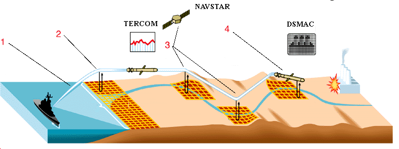
The trajectory of the Tomahawk BGM-109C/D:
- 1 - start;
- 2 - the area of the first correction by the TERCOM system;
- 3 - march area (TERCOM correction using NAVSTAR satellite navigation system);
- 4 - trajectory correction by DSMAC system;
Correlation subsystem TERCOM works on the middle section of the missile's flight path. It includes a computer, a radio altimeter, a set of reference maps of areas along the missile's flight path. The beam width of the radio altimeter is 13-15° (frequency range 4-8 GHz). The principle of operation of the TERCOM subsystem is based on comparing the topography of a particular missile area with reference maps of the topography along the route of its flight. The terrain is determined by comparing data from radio and barometric altimeters. The former measures the altitude to the ground surface and the latter relative to sea level. Information on a particular terrain is digitally entered into a computer, where it is compared with data on the actual terrain and reference maps of areas. The computer provides correction signals for the inertial control subsystem.
The stability of the TERCOM subsystem operation and the necessary accuracy of RC location are achieved by selecting the optimal number and size of cells of correction areas stored in the computer. In this case, the more and the smaller the cells are, the more accurate the terrain, and therefore the location of the CR is monitored. However, due to limited memory capacity of onboard computer and short time to solve navigation problem the nominal size of 120x120m is accepted. The whole CR flight route above the land is divided into 64 correction areas with the length of 7-8 km and width of 48-2 km. The adopted quantitative characteristics of cells and correction areas, according to the American experts, provide a conclusion of the CD to the target even when flying over a flat terrain. Permissible error of terrain height measurement for reliable operation of the TERCOM subsystem should be 1m.
For successful use of Tomahawk missiles, it is considered desirable that the launch area be within 700 km of the shoreline and the first correction area be approximately 48 km wide. The width of subsequent correction areas may be reduced to 9 km and to 2 km near the target. When approaching the first correction area, the TERCOM subsystem is switched on and starts operating. It determines the terrain and compares it with reference maps. As a rule, the measurement data are superimposed on maps of the three nearby areas. To issue a command from the onboard computer to correct the CR course, it is necessary to match two of the three definitions of the subsystem with the reference maps (otherwise the missile will be shot down from the given course). Then the CD, using the inertial control subsystem, continues its flight and goes to the second and subsequent corrections area. The missile "Tomahawk" flies in the mode of bending the terrain above the ground at an altitude of 30-60m (if the terrain is relatively flat) or 150m (hilly). The onboard computer provides the flight program with bypassing the enemy's stationary air defense and missile defense facilities.
After the missile enters the target area, guidance on the final flight path is provided by the DSMAC subsystem. Optical sensors are used to inspect the areas adjacent to the target. Received images in digital form are entered into the computer. It compares them with reference digital images of the areas in its memory and produces corrective manoeuvres for the missile.